Ratings by Roshelle (my new trail rating system):
Dogs spotted: 0
Hike difficulty: don’t bring your dogs unless you want to carry them the whole way up the mountain (on second thought, maybe do bring your five-pound chihuahua if you’ve gotten into weight training recently)
My day started out like any other. I woke up, scrolled through about twenty minutes of Instagram and Twitter feeds, finished some school-related e-mails, and decided to go for a hike. Now, I had a few other errands to run that day and all my other friends were busy so I specifically decided to pick a trail nearby that wasn’t longer than three miles and was not extremely difficult.
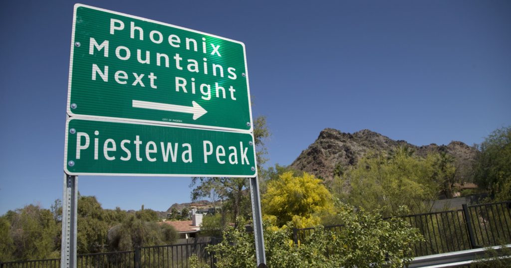
My choice landed on the Freedom Trail in the Phoenix Mountain Preserve. Things started out innocently enough. The trail turned out to be a little less than thirty minutes driving distance from my apartment, was rated moderately difficult on AllTrails (my favorite hiking app by far, 12/10 recommend downloading to find nearby trails), and could be finished in less than two hours. The last factor I was certainly a huge fan of, considering I have a long history of losing track of time (i.e. stopping to take pictures for two hours), and realizing the sun has set as I reach the mountain peak.
If you carefully follow the enormous road signs, you will be led directly into the Phoenix Mountain Preserve. Now, the drive into the preserve may be enough of an incentive to come here, as any trailhead in the park can be found after driving down a winding road between the looming mountains. (Now, I use the term “mountains” loosely, as those of you from more Northern states probably consider a 2,610-foot peak an ant hill. Lookin’ at you, Colorado.) I drove past the first overcrowded parking lot and the second lot on the left. As a bonus, this lot also has shaded picnic tables for the massive meal you should prepare to inhale upon completion of this hike.
Now, if you would like to hike the much milder Freedom Trail (as was my original intention), I was told that by a group of people in the parking lot that you need to start out on the same path as those attempting the Summit Trail. From the parking lot, turn left at the trailhead, and keep walking along the narrow path through the valley for approximately fifteen minutes. Disclaimer: if you want the find the Freedom Trail trailhead, just Google it instead of trusting the word of snowbird tourists. Once you stumble upon the trailhead for the Summit Trail (which you can’t miss because at any given time, there are about three to four out-of-breath hikers celebrating their descent down the mountain by throwing up the Breakfast Club fist here), turn right and follow the path upwards.

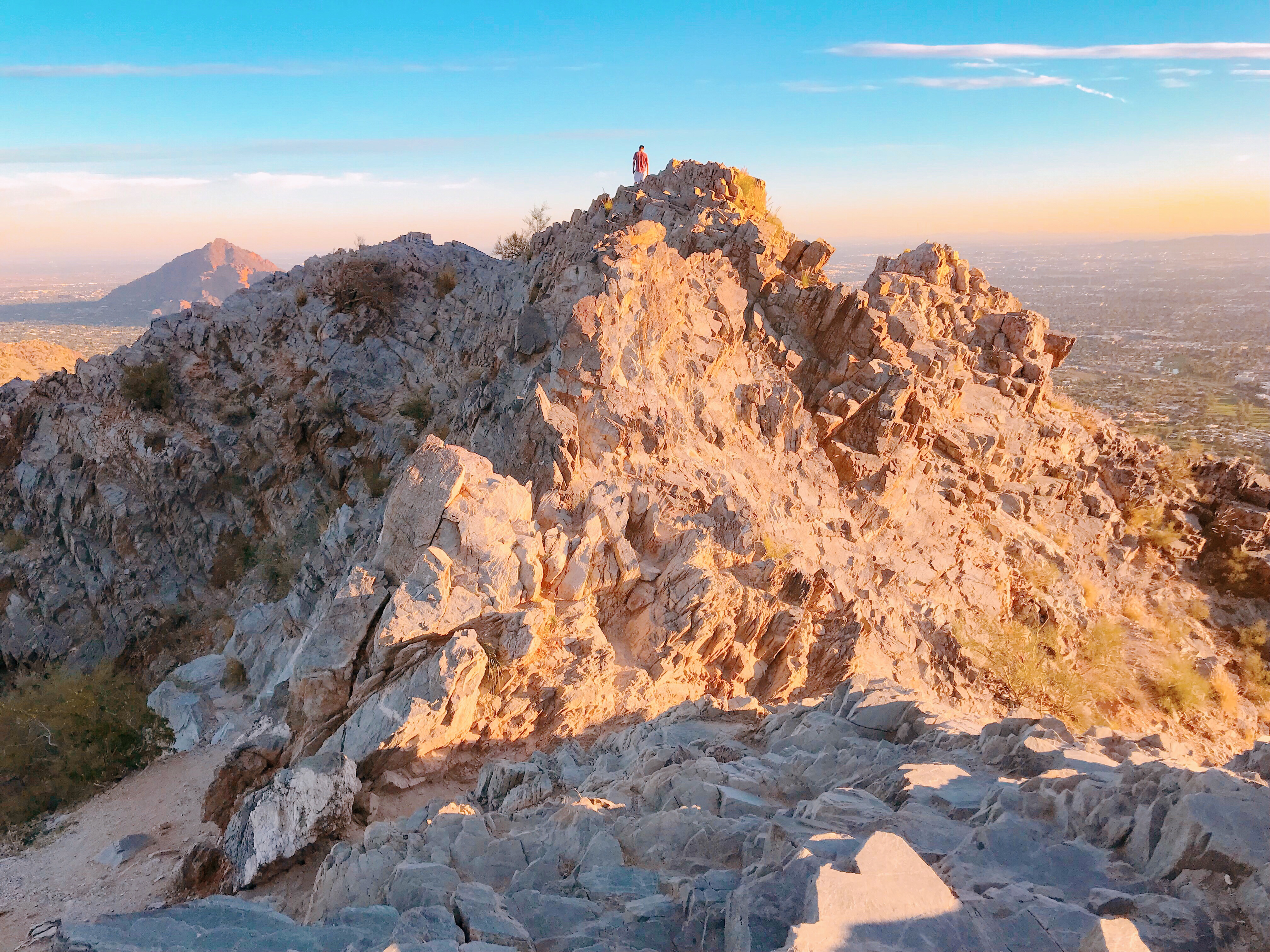
On this next portion of the hike, you will see paved steps (well, not so much “paved” as a mixture of broken gravel, concrete, and dirt) that mark the beginning of a steep ascent. You may ask yourself why I bother sounding so dramatic about a hike that seems so simple: a direct 1.2-mile ascent over a (mostly) paved trail. Keep that question in the back of your mind for the rest of this article. Now, the views from this trail are simply incredible. As you continue the gradual ascent uphill, you will be able to catch views not only of the surrounding Phoenix mountains, but of the entire valley. (Pro tip: come later in the afternoon not only to avoid the heat, but to watch the city of Phoenix gradually light up and begin to twinkle on your way down the mountain.)


The hike should begin to get strenuous pretty shortly. I will warn those of you not exactly in shape: this hike is not for the weak-willed. I consider myself in pretty decent shape (minus the leg muscle atrophy I acquired over the past three months from sitting in the same lecture hall from 8-5 every day), and even I questioned whether I would make it to the peak multiple times. Then again, there were people trail running their entire way to the top so if you happen to be part of those families than run 5k races on Thanksgiving Day, disregard my advice.
I forgot my Garmin running watch at home the day I did this hike, so I don’t have exact distances, but after approximately forty-five minutes into my ascent (and after many photo stops because the views really are incomparable), there should be a fork in the trail with two markers: the 300 trail continues to lead you up to the summit and the 312 trail leads you into some cacti, it looked like. Now, to give you guys a good idea of where I was at, the Freedom Trail marker was nowhere in sight, so you may now kindly disregard this as an article about how to hike the presently nonexistent trail that I had for so long hoped to see a marker for.
As out of breath as you may be, despair not. The hike only gets more difficult from here. This is where you may really start to curse those trail runners that begin to lap you. This is also where 1.2 miles really starts to feel more like 7. But don’t worry, the more heavy breathing you hear from yourself and those around you, the better the views are.

Here are the pro’s and con’s of the Summit Trail thus far. The cons: the lactic acid buildup currently occurring in your legs, the lack of oxygen you will attribute to the 1,200-foot elevation gain (not your lack of commitment to the gym for the past few months), and the lack of dogs around for you to pet. The pro’s: the views. Oh, and the rails some angel provided on the truly difficult portions of the hike to keep you from having to bring rock climbing equipment.
Although the end may never seem near because the peak is entirely hidden from you until the last ten seconds of the hike when you abruptly stumble upon it, I managed, despite my extremely heavy breathing at that point, to ask a middle-aged couple coming down how much further the peak was and they graciously lied to me and told me it was another ten-minute stretch. Maybe they were just trying to be kind and keep me going in my disheveled state or they run 5k’s every other weekend, who knows.
Once you have made it past the second set of railings, the peak should only be a few minutes further (unless you have decided to give up at one of the numerous outlook points and turn back, as I considered doing approximately every five minutes). Although the trail markers on this hike are sometimes few and far in between, the steady flow of climbers up and down the mountain helped ensure that I was going in the right direction at all times. There is a short climbing portion where, if you did decide to ignore the numerous signs along the trail and bring along your chihuahua, you may simply have to throw him up this portion because climbing this will require the use of all four limbs. Thankfully, there are a few grooves carved out, otherwise I would have called in the helicopter at this point. After making it through a V1 rock climbing challenge (any other climbers out there?), you will be faced with one last narrow ascent before you finally reach Piestewa Peak.

And what a reward the final view is. Once you’ve managed to sit down and rest your shaking legs (pro tip: this would be a good point to stretch before you get ready to make the descent), take a second to enjoy the sweeping panoramic views of the mountains and valleys that lay before you.


Once you’ve stretched, given your legs a well-deserved rest, and let your face return back to a normal color instead of beet red, you’re ready to head back down exactly the same way you came. Now you should be invigorated by the thought of making it down (for me, it was to the thought of getting In-N-Out for dinner). It took me a little less than an hour to make it down the mountain – mainly because the sun had begun to set and I only stopped about every five minutes to snag a photo.


My legs started shaking again about halfway down, but I was on a mission to a burger. I powered through and, once I completed the mandatory Breakfast Club fist throw upon getting back to the trailhead, found the energy to trail run another five minutes back to my car. I made it back to the parking lot just to see one last flash of red as the sun completely set over Phoenix and the twinkling city lights greeted me on my way back to civilization.
One response to “Piestewa Peak: A What Not To-Do Guide”
I always love reading your articles! You’re descriptions are always extremely detailed and helpful! It helps that you’re funny as well. Please keep up with the posts!